QUÉBEC, June 2, 2023 /CNW/ – The ministère des Ressources naturelles et des Forêts has decided to prohibit access to the forest in lands in the domain of the State and close roads for public interest for the following seven (7) areas, effective immediately.
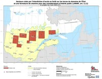
Here is the location map of the affected territory (in French only).
Area 1 (ABITIBI-TÉMISCAMINGUE and NORD-DU-QUÉBEC):
The affected area is a rectangle bounded to the northwest by latitude 49° 37′ and longitude 77° 15′, to the northeast by latitude 49º 37′ and longitude 75° 45′, to the southeast by latitude 48° 07′ and longitude 75° 45′ and to the southwest by latitude 48º 07′ and longitude 77° 15′.
The affected municipalities (or RCMs) are Abitibi (88), La Vallée-de-l’Or (89) and Jamésie (991).
Area 2 (MAURICIE, OUTAOUAIS, ABITIBI-TÉMISCAMINGUE, LAURENTIDES and LANAUDIÈRE):
The affected area is a rectangle bounded to the northwest by latitude 48° 07′ and longitude 76° 00′, to the northeast by latitude 48° 07′ and longitude 74° 45′, to the southeast by latitude 47° 30′ and longitude 74° 45′ and to the southwest by latitude 47° 30′ and longitude 76° 00′.
The municipalities affected are La Tuque (90), La Vallée-de-la-Gatineau (83), La Vallée-de-l’Or (89), Matawinie (62) and Antoine-Labelle (79).
Area 3 (NORD-DU-QUÉBEC and SAGUENAY–LAC-SAINT-JEAN):
The affected area is a rectangle bounded to the northwest by latitude 50° 07′ and longitude 75° 30′, to the northeast by latitude 50° 07′ and longitude 73° 30′, to the southeast by latitude 49° 22′ and longitude 73° 30′ and to the southwest by latitude 49° 22′ and longitude 75° 30′.
The affected municipalities (or RCMs) are Le Domaine-du-Roy (91), Maria-Chapdelaine (92), Jamésie (991) and Oujé-Bougoumou (993).
Area 4 (SAGUENAY–LAC-SAINT-JEAN):
The affected area is a rectangle bounded to the northwest by latitude 48° 52′ and longitude 73° 15′, to the northeast by latitude 48° 52′ and longitude 72° 30′, to the southeast by latitude 48° 22′ and longitude 72° 30′, and to the southwest by latitude 48° 22′ and longitude 73° 15′.
The affected municipalities (or RCMs) are: Le Domaine-du-Roy (91) and Maria-Chapdelaine (92).
Area 5 (SAGUENAY–LAC-SAINT-JEAN):
The affected area is a rectangle bounded to the northwest by latitude 50° 45′ and longitude 72° 45′, to the northeast by latitude 50° 45′ and longitude 70° 45′, to the southeast by latitude 48° 52′ and longitude 70° 45′ and to the southwest by latitude 48° 52′ and longitude 72° 45′.
The municipalities affected are Maria-Chapdelaine (92), Lac-Saint-Jean-Est (93) and Le Fjord-du-Saguenay (942).
Area 6 (CÔTE-NORD):
The affected area is a rectangle bounded to the northwwest by latitude 50° 45′ and longitude 70° 00′, to the northeast by latitude 50° 45 and longitude 68° 15, to the southeast by latitude 49° 22′ and longitude 68° 15′ and to the south-west by latitude 49° 22′ and longitude 70° 00′.
The affected municipalities (or RCMs) are La Haute-Côte-Nord (95) and Manicouagan (96).
Area 7 (CÔTE-NORD):
The affected area is a rectangle bounded to the northwest by latitude 50° 52′ and longitude 67° 00′, to the northeast by latitude 50° 52′ and longitude 65° 00′, to the southeast by latitude 50° 07′ and longitude 65° 00′ and to the southwest by latitude 50° 07′ and longitude 67° 00′.
The municipalities (or RCMs) affected are Sept-Rivières (971) and Minganie (981).
This decision from the Department, taken in conjunction with the Organisation de la sécurité civile and the Société de protection des forêts contre le feu (SOPFEU), is intended to ensure the safety of the affected population and reduce the risk of fire. Non-essential travel is prohibited via forest roads.
The Department would like to remind the public that, at a time when the flammability indices are extreme in all areas of Québec, greater caution is needed to avoid a conflagration. The cooperation of all forest users is essential.
For information on closed areas, please visit the Forest Fires webpage from the Gouvernement du Québec, the SOPFEU website or contact Services Québec toll-free at 1-877-644-4545.
Related links:
For information on the ministère des Ressources naturelles et des Forêts or to learn more about its activities and achievements, visit mrnf.gouv.qc.ca/en or its social networks:
- twitter.com/mrnfqc
- facebook.com/RessourcesNaturellesForets
- linkedin.com/company/ressourcesnaturellesforets
- youtube.com/RessourcesNaturellesForets
- instagram.com/mrnfqc
Information:
Media relations
Ministère des Ressources naturelles
et des Forêts
[email protected]
Tel.: 418-521-3875
SOURCE Ministère des Ressources naturelles et des Forêts


